
22 May

0
553
Στρογγυλή τράπεζα «Αλπινισμός και βουνό μεταξύ Γαλλίας και Ελλάδας: αξίες κοινότητα εξέλιξη»
Οι ομιλίες είναι διαθέσιμες σε βίντεο https://youtu.be/J..
01 Apr

0
68
Η Ανάβαση έφτιαξε τους χάρτες για το Αρχαιολογικό Μουσείο της Καλαμάτας, ενός πρωτότυπου μουσείου με πρωτοποριακή γεωγραφική οργάνωση.
Στόχος της ..
23 Mar
0
1971
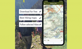
Παρουσίαση της Εφαρμογής "Spartan Trails": Ένας Πλήρης Οδηγός Πεζοπορίας για τον Ταΰγετο και τον Πάρνωνα
Σπάρτη, 20 Μαρτίου 2025 -
Σε μια σημαντική..
13 Sep

0
5295
Η Ανάβαση είναι χαρτογραφική εταιρεία με πάνω από 100 πεζοπορικούς χάρτες και οδηγούς για την ορεινή και νησιωτική Ελλάδα, ενώ αποτελεί αρωγό για την ..
16 Jul
0
3755
Παρουσίαση Βιβλίου "Το Ζαγόρι Μου - Τόπος και Πεζοπορία" στο Φεστιβάλ της Βωβούσας
Δευτέρα 22 Ιουλίου, ώρα 19:00, Βωβούσα Ιωαννίνων
Το Φεστιβάλ της ..
09 Jul

0
3120
Η Ανάβαση δημιούργησε ψηφιακό χάρτη για το Faethon Sky Race, αγώνα τρεξίματος που διεξάγεται στον Όλυμπο. Ο χάρτης βρίσκεται δωρεάν στην εφαρμογή Anav..
19 Jun

0
3567
Μέσα στο Μάϊο η Ανάβαση προχώρησε στη δημιουργία νέας έκδοσης του χάρτη Menalon Trail καθώς και στην ανατύπωση του υφιστάμενου χάρτη του Μαινάλου.
O ..
28 May

0
5344
Οι εκδόσεις Ανάβαση, με αφορμή τον εορτασμό των 20 χρόνων του βιβλιοπωλείου τους, προκηρύσσουν διαγωνισμό ταξιδιωτικής λογοτεχνίας.
Σε μια εποχή που ..
28 May

0
3717
Δύο νέοι τίτλοι κυκλοφόρησαν από την Ανάβαση μέσα στο Μάιο. Πρόκειται για τους χάρτες Οίτη (1:35.000) και Σάμος (1:45.000). Ο χάρτης της Σάμου αποτελε..
02 May
-335x200w.jpg "Μικρές Κυκλάδες: Πεζοπορία στον κρυφό παράδεισο των Κυκλάδων")
0
9091
Οι Μικρές Κυκλάδες αποτελούν σύμπλεγμα νησιών ανάμεσα στη Νάξο και την Αμοργό. Διοικητικά ανήκουν στην Περιφέρεια Νοτίου Αιγαίου στην Περιφερειακή Ενό..
01 May

0
3255
Η Ανάβαση δημιούργησε πεζοπορικό χάρτη για τον Ξενώνα “Αγγελικά στα Ορεινά” στο Καίσαρι Κορινθίας. Ο πεζοπορικός χάρτης στοχέυει στην ανάδειξη της περ..
30 Apr

0
2911
Τρίτη 21 Μαΐου 2024, 19:00
Auditorium Theo Angelopoulos – Γαλλικό Ινστιτούτο Ελλάδος – Σίνα 31
Είσοδος ελεύθερη
Ταυτόχρονη μετάφραση
Βεβαίωση παρακ..