
23 May

0
1865
Άρθρο στο Business daily για τη νέα κυκλοφορία μας:
Κυκλοφόρησε ο νέος αγγλόφωνος οδηγός «Olympic Flowers», που καταγράφει τη χλωρίδα του Ολύμπου, με..
16 Dec

0
5580
ΑΝΑΡΡΙΧΗΣΗ, ΞΕΡΕΙΣ;
Το νέο βιβλίο των εκδόσεων Ανάβαση.
Για νέους που μόλις ξεκίνησαν την αναρρίχηση, αρχάριοι και μη, και θέλουν να μάθουν να σκαρφ..
05 Dec

0
5957
Βιβλιοπαρουσίαση: «Ο Κήπος μας»
Παρασκευή 12 Δεκεμβρίου στις 19:30
Χώρος: Athens Book Space
Πάρκο Ελευθερίας, Βασ. Σοφίας
(δίπλα στο Μεγαρό Μουσικ..
06 Nov

0
4381
υδρόγειος, η (ουσ.)
[από το θηλ. του επίθ. υδρόγειος* ]
1. η γήινη σφαίρα, το σύνολο των ηπείρων και των θαλασσών της Γης
2. (συνεκδ.) η σφαίρα πο..
25 Sep

0
6888
Η Γαλλική Επιστημονική Αποστολή του Μοριά: Ένα Ταξίδι στην Ιστορία και το Μέλλον της Πελοποννήσου
Σχεδόν 200 χρόνια μετά, η σπουδαία Γαλλική Επ..
09 Sep

0
11060
Ο Σεπτέμβριος είναι ο ιδανικός μήνας για πεζοπορικές διαδρομές στην Ελλάδα.
Ο καιρός παραμένει ζεστός για να κάνεις μπάνιο αλλά ο κόσμος και οι καύσων..
05 Sep

0
2252
Γιατί οι Χάρτες και οι Υδρόγειοι σφαίρες είναι απαραίτητοι για την εκπαίδευση των παιδιών
Σε έναν κόσμο που είνια όλο και περισσότερο διασυνδεδεμένο..
27 Jul

0
9115
Σίκινος: Τοπίο και Μονοπάτια, μια Διαρκής Αφήγηση
Η Σίκινος, ένα μικρό νησί που από ψηλά μοιάζει με έναν ομοιόμορφο καμβά, αποκαλύπτει τις αμέτρητ..
30 May

0
7593
Μία πολύ όμορφη συνεργασία με το Σύλλογο Επαγγελματιών Αράχωβας με πινακίδες για πεζοπορικές και ποδηλατικές διαδρομές στα μονοπάτια που υπάρχουν γύρω..
22 May

0
12394
Στρογγυλή τράπεζα «Αλπινισμός και βουνό μεταξύ Γαλλίας και Ελλάδας: αξίες κοινότητα εξέλιξη»
Οι ομιλίες είναι διαθέσιμες σε βίντεο https://youtu.be/J..
23 Mar
0
11217
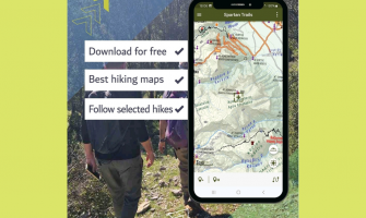
Παρουσίαση της Εφαρμογής "Spartan Trails": Ένας Πλήρης Οδηγός Πεζοπορίας για τον Ταΰγετο και τον Πάρνωνα
Σπάρτη, 20 Μαρτίου 2025 -
Σε μια σημαντική..
13 Sep

0
9265
Η Ανάβαση είναι χαρτογραφική εταιρεία με πάνω από 100 πεζοπορικούς χάρτες και οδηγούς για την ορεινή και νησιωτική Ελλάδα, ενώ αποτελεί αρωγό για την ..