
06 Mar

0
4459
Στις αρχές Μαρτίου κυκλοφόρησαν δύο νέοι τίτλοι καθώς και μία νέα έκδοση χάρτη. Συγκεκριμένα εκδόθηκαν οι χάρτες για τη Λέσβο και για τη Θράκη μαζί με..
23 Feb

0
5498
Στον διαγωνισμό μπορεί να λάβει μέρος κάθε ενήλικας (τη στιγμή της υποβολής), ανεξαρτήτως εθνικότητας και τόπου διαμονής. Από τη συμμετοχή στον διαγ..
21 Feb

0
8030
Tο The Peloponnese Way αποτελεί πεζοπορική διαδρομή μεγάλους μήκους που διασχίζει όλη την Πελοποννησιακή Ενδοχώρα από το Διακοπτό έως τον Άγιο Νικόλαο..
21 Feb

0
1031
To Pindus Way αποτελεί ένα μεγάλου μήκους διαδρομή το οποίο αναφέρεται στον πεζοπορικό οδηγό της Cicerone, Trekking in Greece – The Peloponnese and Pi..
31 Jan

0
9049
Η Ανάβαση είναι χαρτογραφική εταιρία για την ορεινή και νησιωτική Ελλάδα. Με πάνω από 100 πεζοπορικούς χάρτες και οδηγούς. Αποτελεί αρωγό για την αν..
01 Jan

0
16231
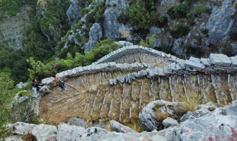
Από την παραθαλάσσια Ναύπακτο ως την τεχνητή λίμνη του Εύηνου, υπάρχει μια περιοχή με εντυπωσιακό ανάγλυφο, η λεγόμενη Ορεινή Ναυπακτία που αντιστοιχε..
29 Nov
0
9073
Αποτελώντας δημοφιλή πεζοπορικό προορισμό, το Ζαγόρι ξετυλίγεται μέσα στις σελίδες του νέου βιβλίου από την Ανάβαση “Το Ζαγόρι Μου – Τόπος & Πεζοπορία..
16 Nov

0
4859
Καταργήσαμε το μη-ανακυκλώσιμο πλαστικό και αντικαταστήσαμε την παλιά πλαστική θήκη με χαρτονένια θήκη χωρίς πλαστικοποίηση
Όσο και να τα έχουμε συνηθ..
08 Nov

0
5704
Μόλις κυκλοφόρησε από τις εκδόσεις Ανάβαση ο Atlas Poétique des Montagnes Grecques, ένας ιδιαίτερος άτλας στα γαλλικά από τον Sylvain Guyot που υμνεί ..
13 Sep

0
5871
Σας παρουσιάζουμε εδώ τον νέο πολιτικό χάρτη της Ελλάδας. Είναι η επίσημη ενημερωμένη έκδοση με όλους τους αναθεωρημένους Δήμους, τις περιφερειακές εν..
23 Aug

0
26064
Μετά από ένα μακρύ ταξίδι με το πλοίο θα φτάσετε στην Ανάφη, ένα μικρό νησί (38 km²), στο νοτιοανατολικό άκρο του Κυκλαδικού αρχιπελάγους. Αυτή η γεωγ..
16 Aug

0
4629
Δύο νέες επανεκδόσεις καθώς και ένας νέος χάρτης κυκλοφόρησαν στις αρχές του Αυγούστου και είναι πλέον διαθέσιμοι τόσο σε ψηφιακή μορφή όσο και σε έν..