
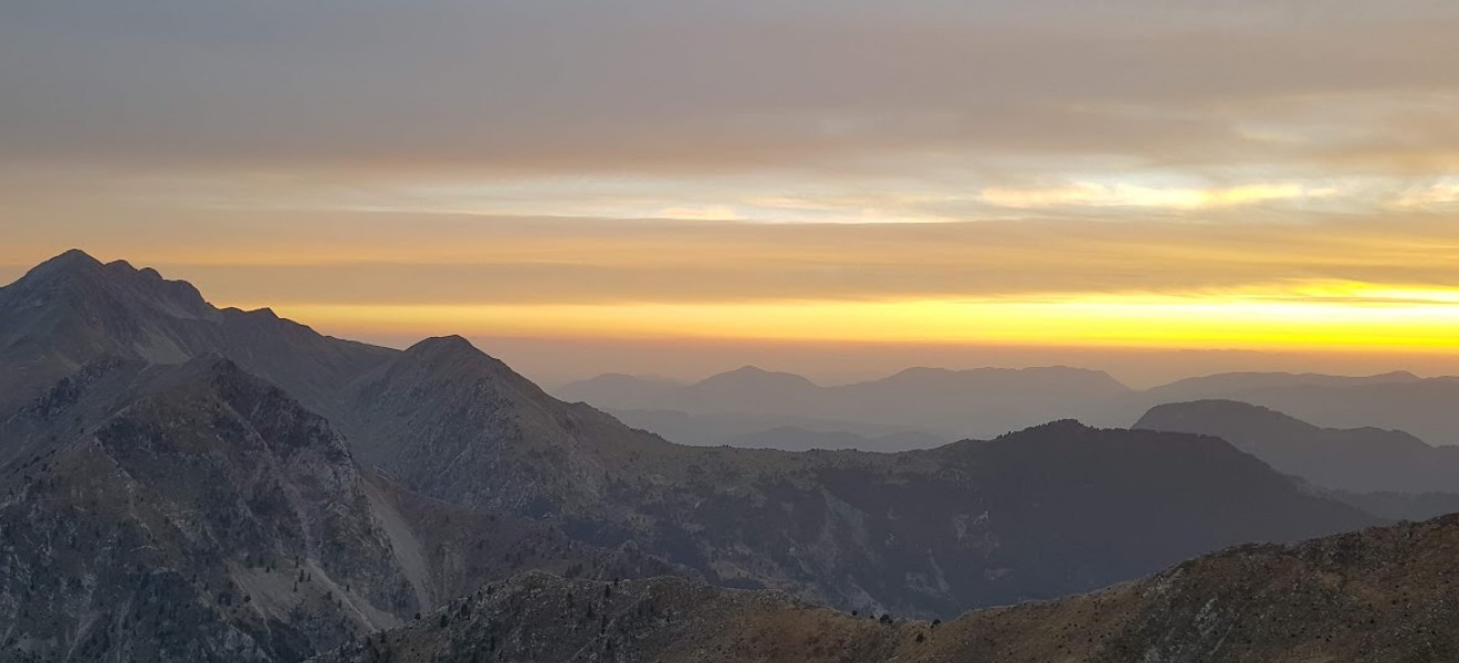
-1320x600w.JPG)
Νέα Ανάβαση stories
22 May

0
553
Στρογγυλή τράπεζα «Αλπινισμός και βουνό μεταξύ Γαλλίας και Ελλάδας: αξίες κοινότητα εξέλιξη»
Οι ομιλίες είναι διαθέσιμες σε βίντεο https://youtu.be/J..
01 Apr

0
68
Η Ανάβαση έφτιαξε τους χάρτες για το Αρχαιολογικό Μουσείο της Καλαμάτας, ενός πρωτότυπου μουσείου με πρωτοποριακή γεωγραφική οργάνωση.
Στόχος της ..
23 Mar
0
1971
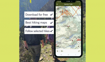
Παρουσίαση της Εφαρμογής "Spartan Trails": Ένας Πλήρης Οδηγός Πεζοπορίας για τον Ταΰγετο και τον Πάρνωνα
Σπάρτη, 20 Μαρτίου 2025 -
Σε μια σημαντική..
13 Sep

0
5295
Η Ανάβαση είναι χαρτογραφική εταιρεία με πάνω από 100 πεζοπορικούς χάρτες και οδηγούς για την ορεινή και νησιωτική Ελλάδα, ενώ αποτελεί αρωγό για την ..
16 Jul
0
3755
Παρουσίαση Βιβλίου "Το Ζαγόρι Μου - Τόπος και Πεζοπορία" στο Φεστιβάλ της Βωβούσας
Δευτέρα 22 Ιουλίου, ώρα 19:00, Βωβούσα Ιωαννίνων
Το Φεστιβάλ της ..


Πεζοπορικός χάρτης της Αλοννήσου σε κλιμακα 1:30000
Η Αλόννησος είναι ένα νησί με πλούσια ιστορία, όπως
μαρτυρούν τα κατάλοιπα των νεολιθικών,..
6.50€
Χωρίς ΦΠΑ:6.50€


Πεζοπορικός χάρτης της Σικίνου σε κλίμακα 1:25000.
Η Σίκινος είναι ένα από τα λιγότερο τουριστικά νησιά των
Κυκλάδων. Ένα τοπίο πραγματικά λιτό..
6.50€
Χωρίς ΦΠΑ:6.50€


Πεζοπορικός χάρτης της Ανάφης σε κλίμακα 1:25.000.
Ο πεζοπορικός χάρτης της Ανάφης [10.47] σε κλιμάκα 1:25 000 από την ΑΝΑΒΑΣΗ θα σας οδηγήσει..
6.50€
Χωρίς ΦΠΑ:6.50€


Πεζοπορικός και αδιάβροχος χάρτης των Σπετσών σε κλίμακα 1:12.500
Χάρτης των Σπέτσων (Σπέτσαι), νησί του Αργοσαρωνικού, σε κλίμακα 1: 12 500 σε τοπ..
6.50€
Χωρίς ΦΠΑ:6.50€


Πεζοπορικός χάρτης των νησιών Μήλος, Κίμωλος, Πολύαιγος σε κλίμακα 1:32.000
Η Μήλος και το αρχιπέλαγός της που περιλαμβάνει επίσης την Κίμωλο, την ..
6.50€
Χωρίς ΦΠΑ:6.50€
 • Πεζοπορικός χάρτης 1:20.000")
 • Πεζοπορικός χάρτης 1:20.000")
Πεζοπορικός χάρτης της Κέας (Τζιά) σε κλίμακα 1:27.000
Νησί με ορεινό ανάγλυφο, πλούσια βλάστηση άφθονα πηγαία νερά και ωραιότατα λιθόστρωτα μονοπά..
6.50€
Χωρίς ΦΠΑ:6.50€
-250x450h.jpg "Νάξος • Πεζοπορικός χάρτης 1:40.000")

Πεζοπορικός χάρτης για τη Νάξος σε κλίμακα 1:40 000
Η Νάξος είναι το μεγαλύτερο και το πιο εύφορο νησί των Κυκλάδων. Το ανάγλυφο του νησιού διαμορφ..
8.50€
Χωρίς ΦΠΑ:8.50€


Πεζοπορικός χάρτης της Θάσου σε κλίμακα 1:36.000
Η Θάσος είναι ένας τόπος προικισμένος σε φυσικούς πόρους και φυσική ομορφιά. Δάση, ορυκτός πλούτος..
8.50€
Χωρίς ΦΠΑ:8.50€
")
City break with beach holidays: Discover Athens with the MARCO POLO Travel Guide Sitting in the street café, where Socrates and Plato once walked, lea..
22.00€
Χωρίς ΦΠΑ:22.00€

ANTIGRAVITY explores the question: Is there a force that defies gravity? In impressive photographs, this book illustrates the story of extraordinary m..
126.14€
Χωρίς ΦΠΑ:126.14€
-250x450w.jpeg "Discover Andros in low gear (book in English)")
In the book, we describe 15 short and fairly light walks. Most walks can be walked in 1.5 to 2.5 hours (net walking time).
Almost every route descr..
21.00€
Χωρίς ΦΠΑ:21.00€

Πυξίδα κλασικής πλάκας βάσης με πλήρη χαρακτηριστικά, με μεγεθυντικό φακό και φωτεινές ενδείξεις.
Η Explorer είναι μια κλασική πυξίδα πλάκας βάσης,..
14.90€
Χωρίς ΦΠΑ:14.90€

Μια ελαφριά και συμπαγής, κλασική πυξίδα με πλάκα βάσης και περιστρεφόμενο στεφάνι με βαθμολογίες δίσκου σε δύο μοίρες, η οποία είναι πάντα στη τσάντα..
11.90€
Χωρίς ΦΠΑ:11.90€

Η πυξίδα Silva Field είναι μια βασική πυξίδα σχεδιασμένη για να καλύψει τις ανάγκες σχολείων, ομάδων νεότητας και αναβατών αναψυχής στην ύπαιθρο.
Η..
26.00€
Χωρίς ΦΠΑ:26.00€

Η ολοένα και πιο δημοφιλής σειρά πυξίδων SILVA Ranger ανεβαίνει επίπεδο στον σχεδιασμό με ενημερωμένα χρώματα και γραφικά. Ένα εντελώς νέο χαρακτηριστ..
48.00€
Χωρίς ΦΠΑ:48.00€

Η διαχρονική σειρά της SILVA, Ranger πέρασε μέσα από μία διαδικασία ανανέωσης των χρωμάτων και των γραφικών της. Και μία νέα προσθήκη: το κορδόνι ανάρ..
35.00€
Χωρίς ΦΠΑ:35.00€
-250x450h.jpg "Ζαγόρι • Βάλια Κάλντα • Μέτσοβο • Πεζοπορικός Χάρτης 1:40 000")

Το Ζαγόρι - Μέτσοβο - Βάλια Κάλντα (1:40 000) είναι ένα έργο σύνθεσης που αποτυπώνει ό,τι γίνεται στην περιοχή για κάθε υπαίθρια δραστηριότητα για το ..
9.50€
Χωρίς ΦΠΑ:9.50€
-250x450h.jpg "Όλυμπος • πεζοπορικός χάρτης 1:30 000 & 1:10 000")

Πεζοπορικός χάρτης του Ολύμπου σε κλίμακα 1:30 000 και της κορυφής του Μύτικα σε κλίμακα 1:10 000
Ο Όλυμπος είναι το ψηλότερο βουνό της Ελλάδας με..
9.50€
Χωρίς ΦΠΑ:9.50€


Πεζοπορικός χάρτης της Νότιας Πίνδου, Τζουμέρκα, Περιστέρι, Κόζιακας, σε κλίμακα 1:50.000
Ο πεζοπορικός χάρτης Νότια Πίνδος [3.2/4.2] Περιστέρι - Κ..
9.50€
Χωρίς ΦΠΑ:9.50€
, Σμόλικας, Βόιο, Βασιλίτσα • Πεζοπορικός χάρτης 1:40 000")
, Σμόλικας, Βόιο, Βασιλίτσα • Πεζοπορικός χάρτης 1:40 000")
Πεζοπορικός χάρτης για το Γράμο, το Σμόλικας, το Βόιο και τη Βασιλίτσα σε κλίμακα 1:40 000.
Η ψηλότερη κορυφή είναι η Τσούκα Πέτσικ με υψόμετρο 252..
9.50€
Χωρίς ΦΠΑ:9.50€
-250x450h.jpg "Λευκά Όρη - Σφακιά / Πάχνες • Πεζοπορικός χάρτης 1:25.000")

Πεζοπορικός Χάρτης Λευκά Όρη - Σφακιά / Πάχνες σε κλίμακα 1:25.000
O νέος πεζοπορικός χάρτης Λευκά Όρη - Σφακιά/Πάχνες περιλαμβάνει όλο το συγκρότ..
9.50€
Χωρίς ΦΠΑ:9.50€


Πεζοπορικός χάρτης για τα Άγραφα σε κλίμακα 1:50 000
Ο νέος χάρτης Άγραφα σε κλίμακα παρουσιάζει για πρώτη φορά σε μία όψη ολόκληρη την οροσειρά τω..
9.50€
Χωρίς ΦΠΑ:9.50€


Νέος και ενημερωμένος το 2024 πεζοπορικός χάρτης για την Πάρνηθα σε κλίμακα 1:25 000.
Στο πίσω μέρος του χάρτη υπάρχει χάρτης σε κλίμακα 1:10.000 γ..
9.50€
Χωρίς ΦΠΑ:9.50€


Πεζοπορικός χάρτης των βουνών Γκιώνα και Βαρδούσια σε κλίμακα 1:25.000
Ο χάρτης Γκιώνα - Βαρδούσια 1:25.000 δεν είναι η νέα έκδοση του χάρτη Γκιώνα..
9.50€
Χωρίς ΦΠΑ:9.50€