
01 Apr

0
68
Η Ανάβαση έφτιαξε τους χάρτες για το Αρχαιολογικό Μουσείο της Καλαμάτας, ενός πρωτότυπου μουσείου με πρωτοποριακή γεωγραφική οργάνωση.
Στόχος της ..
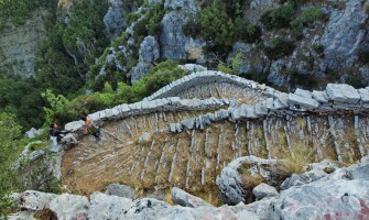
13 Sep

0
5287
Η Ανάβαση είναι χαρτογραφική εταιρεία με πάνω από 100 πεζοπορικούς χάρτες και οδηγούς για την ορεινή και νησιωτική Ελλάδα, ενώ αποτελεί αρωγό για την ..
31 Jan

0
2907
Η Ανάβαση είναι χαρτογραφική εταιρία για την ορεινή και νησιωτική Ελλάδα. Με πάνω από 100 πεζοπορικούς χάρτες και οδηγούς. Αποτελεί αρωγό για την αν..
29 Nov
0
4482
Αποτελώντας δημοφιλή πεζοπορικό προορισμό, το Ζαγόρι ξετυλίγεται μέσα στις σελίδες του νέου βιβλίου από την Ανάβαση “Το Ζαγόρι Μου – Τόπος & Πεζοπορία..
15 Apr

0
3124
Συνεχίζοντας δυναμικά το έργο της το 2023, η Ανάβαση προχώρησε στην επανέκδοση 6 χαρτών. Οι νεές εκδόσεις περιέχουν νέες διαδρομές που διέσχισαν οι πε..
24 Mar
-335x200h.png "Τήνος: Νέα Ενημερωμένη Έκδοση")
0
2480
Τα τελευταία 13 χρόνια έχουμε καταγράψει περισσότερα από 450 χιλιόμετρα μονοπατιών στην Τήνο. Επιλέξαμε και προτείνουμε 16 διαδρομές, οι περισσότερες ..
16 Mar

0
2367
Ο χάρτης διαφέρει από τον χάρτη της Νάξου & των Μικρών Κυκλάδων. Δεν είναι μια ενημερωμένη έκδοση που ήρθε να αντικαταστήσει την προηγούμενη. Άλλ..
02 Feb
-335x200w.jpg "Πινακίδες στην Ανάφη")
0
3452
Έχοντας κλείσει 25 χρόνια στη δημιουργία πεζοπορικών χαρτών για όλη την Ελλάδα, η Ανάβαση προχώρησε στη δημιουργία πινακίδων με πεζοπορικό χάρτη στην ..
02 Feb

0
2664
Έχοντας κλείσει 25 χρόνια στη δημιουργία πεζοπορικών χαρτών για όλη την Ελλάδα, η Ανάβαση προχώρησε στη δημιουργία πινακίδων με πεζοπορικό χάρτη στην ..
30 Jan
-335x200h.png "Νότια Κυνουρία: Δημιουργία Πεζοπορικού χάρτη με το Δήμο")
0
2972
Ακολουθώντας πιστά το έργο της στη δημιουργία πεζοπορικών χαρτών, η Ανάβαση προχώρησε στη δημιουργία πεζοπορικού χάρτη σε συνεργασία με το Δήμο Νότιας..
02 Dec

0
6058
Συνεχίζοντας δυναμικά το έργο μας και το 2022, κυκλοφορήσαμε στα τέλη του Νοεμβρίου τις νεές εκδόσεις των χαρτών Πάρος, Ταϋγετος, Εύβοια και Χανιά. Σε..
16 Nov

0
2178
Ως συνέχεια της δραστηριότητας που αναπτύχθηκε στο πλαίσιο του προγράμματος «Μονοπάτια Πολιτισμού» της Ελληνικής Εταιρείας Περιβάλλοντος και Πολιτι..